 |
| Mt. Greville |
Here's a walk that I never got around to posting from last year. Directions for getting to the carpark of Mt. Greville and the start of the track can be found in my previous report about Palm Gorge here. Ever since completing that first walk Mt. Greville has been a bit of a favourite location of mine. I've since taken some family up Palm Gorge and have been back a couple of times rock climbing in Waterfall Gorge. However, until this point I still hadn't been all the way up via this route.
After starting up the same track as for Palm Gorge you reach an intersection with Waterfall Gorge signed as the right fork. The track from this point is quite rocky and loose with some steep sections while you climb a small ridge. Once attaining the ridge you get a great view up into Waterfall Gorge before dropping down to its start via a steep (sometimes muddy) section.
A creek runs the length of the gorge however depending on the recent weather the water runs underground for most of the walk. Cliffs line the gorge for most of its length and the terrain is reasonably steep with some sections of scrambling.
 |
| Some small sections of scrambling |

 |
| Still plenty of palm trees |
Track notes from Take a Walk: in SE Queensland indicate the main difficulty on this walk being the waterfall near the top of the gorge. I wasn't sure what to expect, but what we found definitely wasn't the most imposing set of falls. We simply walked up the "falls" directly and then scrambled up to the left for the final section. You could also veer left at the base of them to avoid the small scramble.
 |
| The Falls (the tree is lying on the ground, not upright ;)) |
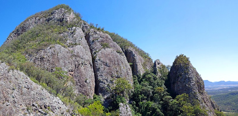
From the top of the falls it isn't long until you reach the head of the gorge. We stopped here for lunch where there is a good view towards Mt. Moon and the range. At this point you can detour from the summit track by heading up to the right along a well worn foot pad. This takes you to an excellent lookout (where the title photo was taken).
Back at the top of the gorge you can head left and follow a series of footpads and tape markers back to the top of the South-East Ridge, then onto the top of Palm Gorge and finally on to the summit if you wish (see this post for details on Palm Gorge and the South-East Ridge). For this trip we decided to descend down Palm Gorge to avoid the heat. No matter which way you choose, you're in for a treat.
 |
| Exposed roots on the way down Palm Gorge |
- Mt. Edwards
- Mt. Mitchell
No comments:
Post a Comment