Thursday, 23 June 2011

Mt. Greville

Date: 19/6/2011

Walkers: Maree, Myself

Walk Description:
Ever since walking up Mt. Edwards last year I had wanted to get out to the slightly more impressive Mt. Greville. Standing at 770m it is one of the tallest of the Moogerah Peaks. We were following track notes from Take a Walk in S.E. Qld and at the end of the day were very happy with the route, which provided the best directions of travel for the views and terrain we encountered.
 
The trip from Ipswich took roughly an hour and a half with a breakfast stop along the way. The entrance to the National Park is on the South-East side of the mountain and consists of a small grassy carpark. After making some final gear adjustments we set off along the track following signs for Palm Gorge. This first section of the track followed an old management road beside a fence line until it eventually veered off to the right along a narrower foot pad.

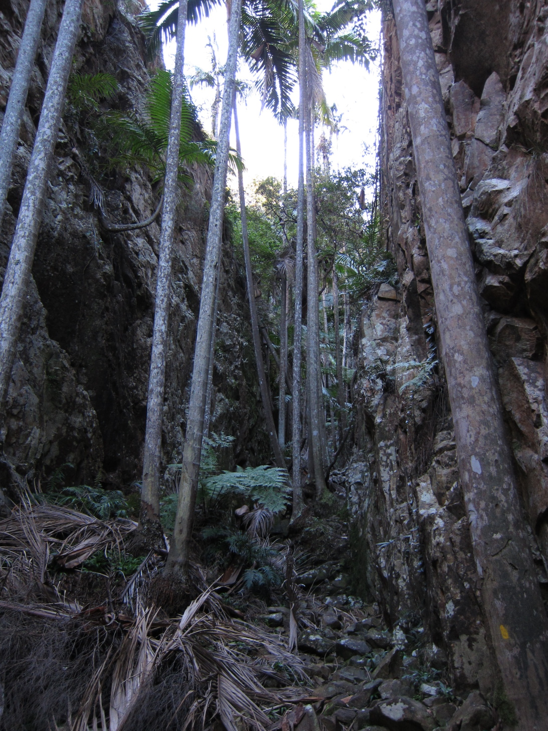
Massive Palms in the Gorge
The vegetation became very lush as we headed up hill and we could gradually see the walls of the gorge closing in until eventually its width would have been less than ten metres across. The name of the gorge was well deserved with numerous palm trees all stretching as high as they could to catch the sunlight at the top of the cliffs. The ground was very rocky and covered with palm fronds making progress slow in some sections. The gradient was reasonably steep and consistent most of the way up the gorge until we reached its head and the main track junction for the other routes up.

This fella was bigger than my hand. Some sort of Golden Orb?
Narrow Section of the Gorge
From here the vegetation dried out and more low shrubs crowded the track. Within a few minutes we reached a short side-track off to the left which gave us a good view towards the Main Range from the top of a steep rocky gully. After returning to the track we continued upwards towards the peak. The number of grass trees increased as we climbed higher and after negotiating a few steep sections of the track we reached the large cairn marking the peak. Views from the peak were largely obstructed by  trees, however as the notes instructed there were great views from a rocky outcrop to the West. 

Mt. Edwards & Lake Moogerah from the Peak
Grass Tree Flowers
After taking some photo’s we chose a rock each and had lunch before heading back the way we’d come. When we reached the junction at the top of the gorge we took the other option which headed towards the top of the South-East Ridge and our route down. The foot pad down this section wasn’t always obvious because of the large amount of rock slabs but the ridge was fairly easy to follow and provided a stark contrast to the track we’d taken on the way up. There were plenty of views across to Mt. Moon, the Main Range and even all the way through to Mt. Barney. The gradient was fairly easy going most of the way down except for one steep, loose and rocky section.


South-East Ridge
Before long we had reached the main track junction again and it was only another couple of hundred metres back to the car. Overall I’d rate this as one of my favourite day walks in S.E. Queensland so far. The variation and uniqueness of the terrain and foliage within the one walk was amazing and I will definitely be heading back to explore Waterfall Gorge.
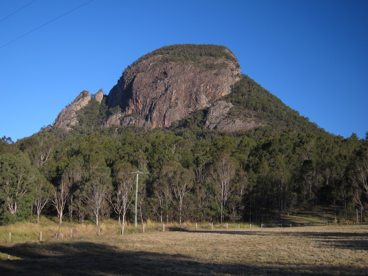
Mt. Greville

Saturday, 11 June 2011

Main Range, Mt. Lindsay and Wild Oasis

Here's a few pictures from yesterday's adventures.

Creek Crossing #3
This was the road to the start of our intended walk yesterday near The Steamers on the Main Range and was the point where we started to get worried about whether we would reach our intended destination in the 2wd Tuscon. Damn that water was cold!!

Creek Crossing #4
This is where we did in fact decide that we weren't going to reach the start of the walk and turned around.

Mt. Lindsay from the Highway

Mt. Lindsay from Barney View Rd.
These photos were taken on the way to Mt. Barney after driving through Killarney and up the Mt. Lindsay Hwy. We eventually decided to cut our losses and head for home.

The upside was that we got home with enough time to to have a play with the latest piece of gear to arrive. I picked up a Six Moon Designs Wild Oasis tarp shelter second hand off the bushwalking forums. I had been thinking of trying out a Pyramid type shelter and when this popped up it was perfect. Weight is 400g which includes the perimeter bug netting and guylines. Adding a 100g Tyvek ground sheet and 6 pegs for 50g makes a 550g single person, mostly bug proof shelter.

Not having a fixed floor means the pitched height can be changed depending on the conditions. When pictched moderately higher there is plenty of room for sitting up and for sleeping inside. Entry and exit is easy aswell. When pitched to the ground for bad weather the space is limited so I would only do this in very bad weather. Hope to get out for a proper test run soon. 


Sunday, 8 May 2011

Mt. Cordeaux & Bare Rock

Mt. Cordeaux Peak from the Lookout
Date: 7/5/2011

Walkers: Maree, Myself

Walk Description:
Mt. Cordeaux, along with Mt. Mitchell, are the two peaks that stand over each side of Cunningham's Gap in the Main Range National Park. With a stunning Autumn day the decision to head out for a walk was extremely easy to make. The drive from Ipswich took about an hour and we arrived at the top of the gap by about 10AM. This was despite the large road works heading up the range reducing the traffic down to one lane.

The  temperature was much cooler up in the shade of the rainforest so we were keen to get going and warm ourselves up. The track started along the Rainforest Circuit at an easy uphill gradient and it wasn't long until we were greeted with a familiar panorama from the first lookout to the East. From here we continued along the rainforest circuit until we reached the track junction to divert us to our destination of Mt. Cordeaux and Bare Rock.

From here the track continued steadily uphill as we tracked North-West along the side of the moutain before switching back and heading towards the peak lookout. As the track climbed higher there were some great views to the South, showing us a different aspect of Mt. Mitchell.

The vegetation on the more exposed slopes in this section had opened up and comprised of a combination of low shrubs, grass trees and very large succulents. Throughout the walk there was also a large variety of mosses.

The Mt. Cordeaux lookout provided a near 360 degree view, only excluding the North-West to North region which was blocked by the peak itself. We arrived here by about 11:30 and stopped for morning tea before continuing on towards Bare Rock. The track detours around the Western side of the peak where you get a good view of the cliffs surrounding it. This is the reason that the track dosn't actually reach the true summit.


Mt. Cordeaux Peak from the North
On the Northern side of the peak the track followed the top of a narrow ridge that connects the mountain with the rest of the range. From here there were more views to the East as well as back to the peak. The track then continued through lush vegetation for another hour or so before reaching the junction for Morgan's Lookout. At this point we decided to head for Bare Rock for lunch, and were glad we did. The view from Bare Rock was once again a near 360 degree one with good outlooks towards Castle Mountain and further along the range.

By contrast the view from Morgan's Lookout was fairly overgrown. We followed our same path back to the car except for a couple of stopover's and detours. The first was for a trip up to the peak of Mt. Cordeaux. The "Take a Walk" guidebook advised that the best way to attempt this was from the Northern end. I bush bashed my way to the base of the cliff line on the Western side and tracked North along the cliffs until I found a possible way up. It was a very steep scramble/climb and apart from the point of reaching the top, probably wasn't worth it. The top was mostly covered by vegetation and didn't provide any additional outlooks.

The only other variation we made on the return journey was to continue around the other half of the rainforest circuit. Great way to spend an amazing day.


Moss Covered Tree

Thursday, 28 April 2011

New Zealand Snapshot

Not really in SE Qld I know, but I thought this was worth mentioning anyway. I recently got the chance to take a short trip to New Zealand. Of course we didn't let the opportunity to do some hiking and camping go past. We only had time to spend a few days doing these activities but it was well worth it.

Tongiraro National Park:
I had been really looking forward to going here. The park is the oldest National Park in NZ and is based around three volcano's one of which, Mt. Ruapehu, is the highest mountain in the North Island at 2797m and bigger than anything we have in Australia. We had been hoping to do the most popular walk in the park, the Tongiraro Alpine Crossing. However, on arrival it became fairly obvious that this wasn't going to be possible. The forecast for the weather was looking fairly bleak with a high chance of snow, high winds and low temperatures. So we decided that we'd play it by ear the next day and probably do one of the shorter walks.

Well the next day we awoke to freezing rain and wind at the campsite but by the time we packed up and reached the ski village this had turned to snow. We decided to head up the now closed road to where the ski lifts start and head back along the Silica Rapids track. This was a very memorable walk and was my first look at real snow. The weather did get pretty hairy with some very strong winds but it was all worth it. Here are a few photo's.

Bruce Road
Silica Rapids Walk

Silica Rapids Walk

Waihi Beach:
The next day we were in for a massive change in weather. We spent a day and a half at Waihi Beach on the North coast. We spent most of the day doing a walk along the cliffs above the water to Orokawa Bay and then up off the beach to William Wright Falls. This was a beautiful and fairly easy going walk with great views out to the Bay of Plenty from the cliffs. Orokawa Bay itself is only accessible by foot but there was still a handful of people relaxing on the beach.

The side track up to the falls went through rainforest with many creek crossings along the way. The falls were picturesque despite the small amount of water and we stopped for lunch here before heading back the way we'd come.


William Wright Falls

Wednesday, 27 April 2011

Welcome

Welcome to the all new and improved blog site. The move was done for a variety of reasons but mainly because of the more modern format. I've moved most posts over. Check the post body for the actual date of the walk.

Albert River Circuit

Date: 5 March 2011

Walkers: Kurt, Tom, Mary, Myself

Walk Description:
Now that Summer is finished, the heat is easing up (supposedly) and bush camping at Lamington NP is re-opened we thought it was about time to get out for an overnight walk again. This would be Kurt's friend Mary's first bushwalk so we decided to make it a completely on-track walk leaving from O'Reillys, walking the Albert River Circuit anti-clockwise, camping at Bithongabel and returning via the Tooloona Creek circuit or taking the shorter way back along the border track depending on how we felt.

The weather leading up to the weekend wasn't looking too promising with rain for most of the week. The forecast for the weekend indicated that the rain would ease on Saturday and probably clear up on Sunday. We also decided to call the ranger on Friday afternoon to see what the weather was like up on the plateau. Taking all this into account and checking the forecast one more time on Saturday morning we decided to go ahead with the walk. Tom and I arrived later than we had planned at around 9:40AM to see Kurt and Mary waiting for us. So we quickly geared up and headed off.

This was going to be a great opportunity for Tom and I to test some new gear. I was using my 36L Golite Peak which Tom had kindly retrofitted some hip belts from another pack on the car ride there in the morning. Tom was using his new BackPacking Light Absaroka Pack and it was the first time out using the Tarptent Scarp 2 tent. Combined with various other bits and by scrutinising our gear list Tom and I's total pack weights came in at 10KG and 8KG respectively.

As we set off along the border track there was a very fine misting of rain which was mostly blocked out by the thick rainforest canopy. After following the well trodden path for roughly 5KM we arrived at the first track junction for the Albert River Circuit. This lead us up and eventually over the ridge to the East before decending down the gully to the edge of Black Canyon where the Albert river runs. The rain had picked up during this time and each time we crossed a creek or came out from under the canopy it was heavy enough to warrant getting out our wet weather gear. For myself this was an opportunity to test out a new Golite Poncho Tarp.

DSCF1095By the time we got to the first waterfall along the Albert River it was time to stop for lunch. This was a reasonably stressful stop with no where dry to sit and no 2 seconds passing by without a leech reaching some section of unprotected skin. The falls however, had plenty of water and made for a good photo opportunity.


For the next couple of kilometres the track criss-crossed the river which, despite the amount of water, was negotiated without too many hassles. Eventually the track climbs up the other side of the gully towards Echo Point. As we approached Echo Point from the camp site it became abundantly clear that there wasn't going to be much of a view; which was confirmed upon arrival. On top of the cloud and rain we were exposed to the very strong Southerly wind, so we took a few photos and kept moving.


DSCF1097
The next section of the track skirts along the top of the cliffs before heading back up towards the border track. By this stage the rain had most definitely set in and was not letting up. The poncho was working better that I had hoped. It was keeping my top half nice and dry while also providing plenty of ventilation to minimise discomfort from sweating. The bottom half wasn't kept as dry as it could have been though and the loose nature of the item meant that I was collecting leaches around my arms and neck.


By 4PM we had once again rejoined the border track and the decision was made to call it a day and head back the last 5KM to the cars. The campsite was going to be exposed to similar windy conditions as Echo Point and the rain wasn't looking like it would let up, so basically we chickened out. By the time we arrived back at the cars we were all fairly glad that we had made that decision. We pulled off the remaining leaches, got changed into whatever dry clothes we had, cranked the car heaters and headed for home.

DSCF1099


As usual, the walking at O'reillys was beautiful despite the conditions and we were still glad we made the effort. We covered just under 21KM with overnight packs and it was great to get back out after the Summer break.


Mt. Barney Lower Portals


Date: 30 Dec 2010

Walkers: Tom, Tenelle, Maree, Myself

Photo Album

Walk Description:
Well the rain finally let up and we were all on holidays so we jumped at the chance to get out and do something outside for a change. We decided to head down to Mt. Barney again, however unlike previous visits opted for a more relaxing walk out to Lower Portals.

We arrived at the carpark and headed off by about 10:30 in the morning. The track was about 3.8KM each way and followed the base of the mountain dropping in and out of numerous gullies with creeks of varying sizes. At various points the cicada's were almost deafening and covered the sides of the trees spraying us as we went past.

We eventually arrived at Barney Creek to find the water rushing past. After investigating up and down the creek for a way to cross without getting wet we decided that it wasn't going to happen so got changed into our swimming gear. At the Lower Portals themselves the water was flowing slower because of the depth and the swimming was very nice on a humid day.

While sitting by the creek we spotted some brush tailed rock wallabies and after lazing around for the rest of the afternoon and avoiding the eels we eventually headed back to the car for the trip home.

Looking up towards the Lower Portals with Leaning Peak in the background
Barney Creek